Search
#lovewānaka
Featured Activities

This land has a rich history.

5 million years ago earth’s movements established the main elements of today’s landscape, such as the schist that forms the Southern Alps. During the ice age glaciers carved deep U-shaped valleys that are distinctive to this region. Glaciers covered the region and are what today’s landscapes have been formed by.

From the time of Waitaha arrival who journeyed on the Uruao waka to be the first people of Te Waipounamu / South Island, Kāi Tahu Whānui have lived off the land, from the land, with the land and across the land. Forging deep connections to whenua and environment.

Next came the early European explorers like Nathaniel Chalmers, and the prospectors who followed drawn by the allure of gold, to the people of today who nurture a deep love for this unique place.

Behind this sits a host of characters and an abundance of stories. It is with respect to the past and the people before us that we seek to understand as much as possible to become better custodians of this place.

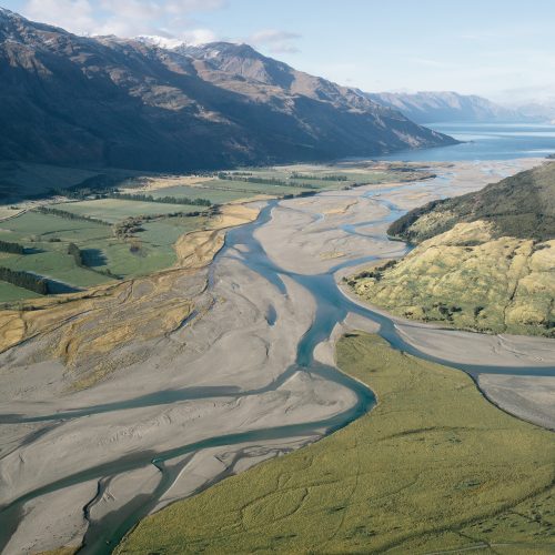
Geological changes have had a significant influence on the formation of waterways and the land in this region. The present valleys of the area were carved by glaciers. There were various sequences of glacial and warmer periods, with the last glacial maximum occurring around 15,000 years ago. Rock debris (till) carried by these glaciers was deposited when they melted, and this material now dams all of the large southern lakes. This process resulted in a complex mixture of sorted alluvial deposits and mixed glacial materials in the plains in the southern part of the Upper Clutha, most notably south of Hāwea.


The schist rocks which dominate the geology of the Central Otago and Upper Clutha areas were deposited around 130-250 million years ago. The gold which defined much of the early European history of the area was deposited from hot water solutions in similar conditions over the last 140 million years.


Geological changes have also had a significant influence on waterways in the region, much of the present Upper Clutha catchment once flowed south to the Kawarau via the Cardrona and Motatapu valley, before uplift in and near the Crown range cut off this flow path.


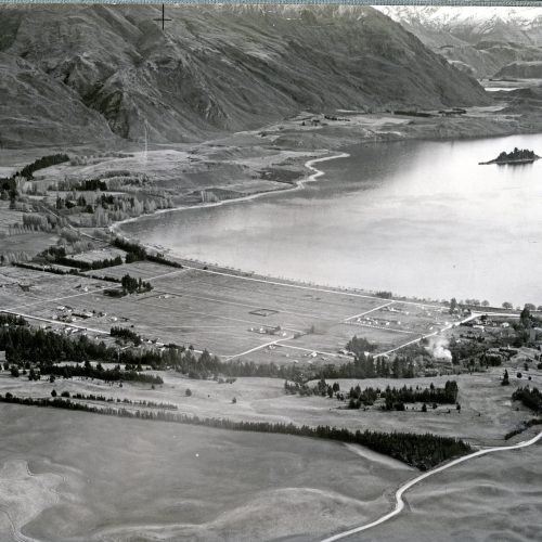
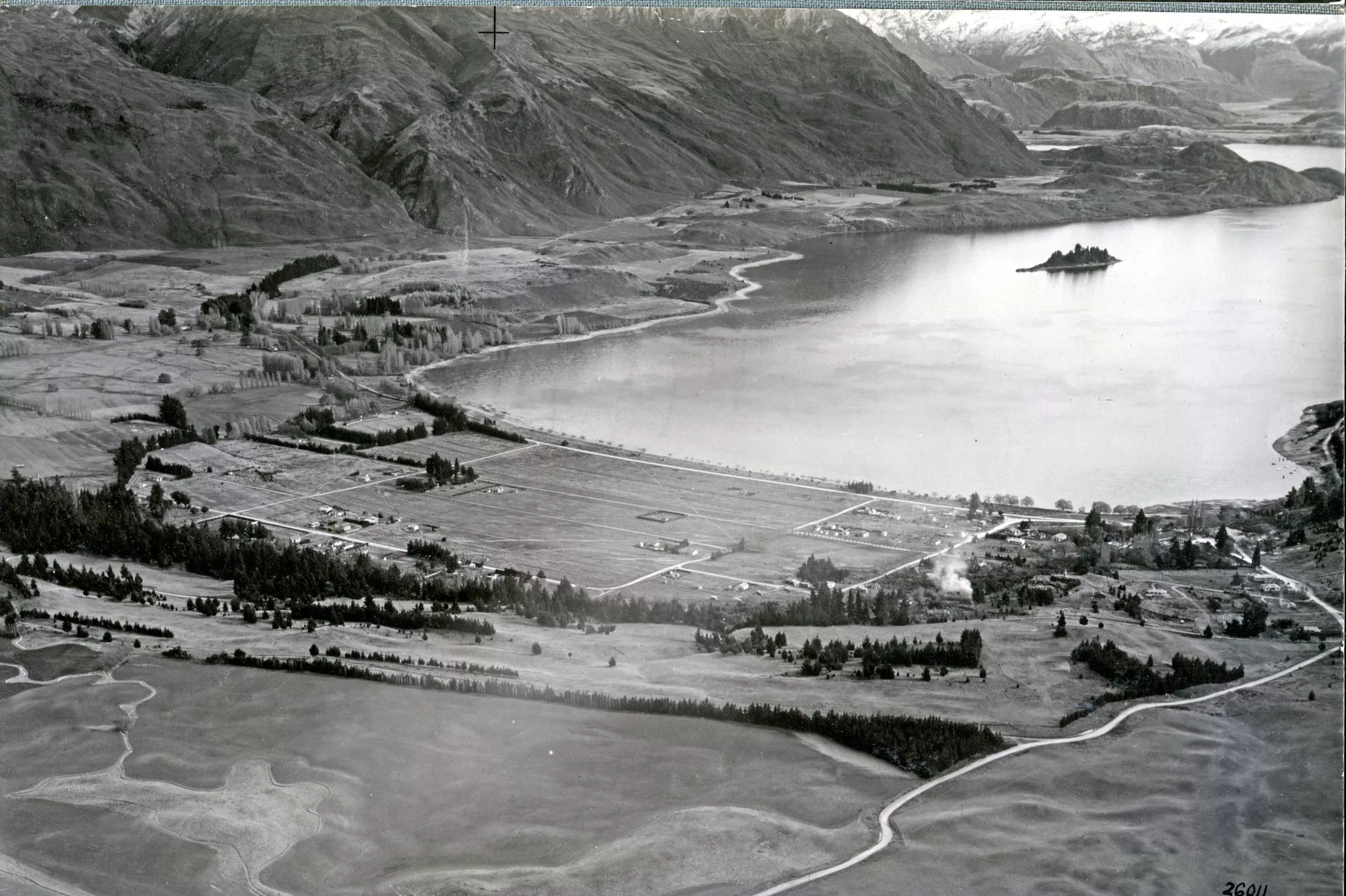
The town of Wānaka is situated at the southern end of Lake Wānaka on one of the till dams and surrounded by mountains. To the southwest is the Crown Range and town of Queenstown; to the north the Haast Pass cuts through the Southern Alps near Makarora. Very close to Lake Wānaka is Lake Hāwea, in a parallel glacial valley, which has a recently developed settlement of about 1,500 people.


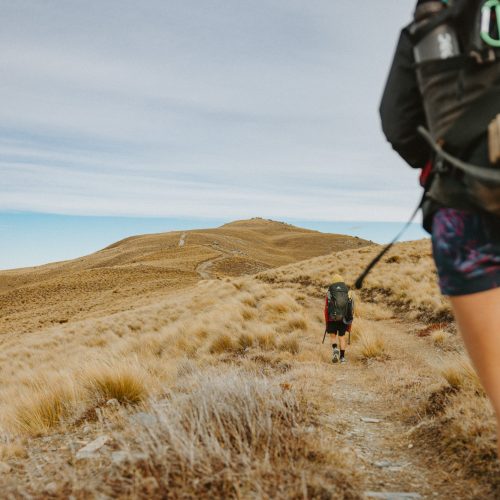
To the south and north of the town lies more of the Southern Alps and the Matukituki and Makarora River valleys which gives access to the Mount Aspiring National Park, part of Te Wahipounamu World Heritage Area. This is a mixture of native bush and alpine landscapes, with some glaciers. The catchment boundaries in this area are defined by large peaks, most notably Mt Aspiring/Tititea (3,033 m).

Wānaka and Hāwea are iconic lakes of cultural and statutory significance to Kāi Tahu. The lakes feature in the Waitaha iwi oral tradition of “Kā Puna Wai Karikari o Rākaihautū” which tells how the great lakes of Te Wai Pounamu (the South Island) were dug by the tūpuna (ancestor) Rākaihautū with his famous kō (Polynesian digging tool). Rākaihautū was the captain of the waka (ocean canoe), Uruao, which brought the Waitaha people to New Zealand on an early discovery expedition. It is Rākaihautū and the Waitaha people who lit the first fires of occupation within Te Wai Pounamu.

Around Lake Wānaka were a number of pā (strongholds), kāika (settlements) and nohoaka (camp sites). The biggest known settlement in the area was a Kāi Tahu pā known as Take Kārara which was located in present day Roys Bay. Other local settlements included Ōrau which was on the banks of the Cardrona River, Toka Karoro towards Beacon Point and Okai Tū situated where the Clutha and Hāwea Rivers meet. A highly significant site for spiritual and traditional reasons was Manuhaea, located below The Neck, the narrow isthmus between lakes Wānaka and Hāwea.


The name “Wānaka” is a South Island variant of the word “wānanga” which refers to ancient schools of learning. In these schools Kāi Tahu tohuka (men of learning) would be taught whakapapa (genealogies) which stretched back to over a hundred generations and karakia (incantations) for innumerable situations. All of this learning they would be required to commit to memory.

Trails (ara tawhito) in the area included: the Clutha/Mata-au, used to transport pounamu and mahika kai (natural and cultural resources) back to the coast; the Waitaki River, Ōmakō/Lindis Pass which connected the Waitaki with lakes Wānaka and Hāwea; the Matāura River, noted for its indigenous fishery; and Haast Pass/Tiori Patea.


The Mātakitaki River provided an alternative route to the treasured pounamu resources of Te Tai Poutini/the West Coast. The Ōrau (Cardrona River) and the Kawarau were also part of this interconnected network of trails. At Whakatipu-wai-Māori (Lake Wakatipu) a network of villages lay along the routes to access pounamu at Te Koroka, located beyond the head of the lake. Countless generations transported it back to coastal settlements in Otago and Southland on waka and mōkihi for fashioning into tools, ornaments and weapons.


Tititea was located on the south side of the Kawarau River, near Ōterotu. Whakatipu-Wai-Māori is an important source of freshwater, the lake being fed by hukawai (melt waters). These are waters
with the highest level of purity and were accorded traditional classifications by Kāi Tahu that recognised this value. These Tapu (sacred) waters sustain many ecosystems important to Kāi Tahu.


All elements of the natural environment possess a mauri, a life force, and all forms of life are related. The mauri of whenua and wai taoka, lands and waterbodies, represent the essence that binds the physical and spiritual elements of all things together, generating and upholding all life. Mauri is therefore a critical element of the spiritual relationship of Kāi Tahu Whānui with the whenua, waterbodies and resources of the region.


Kāi Tahu understand climate change through this paradigm of connectedness and relationship with the environment. The tūpuna (ancestors) had considerable knowledge of whakapapa, the traditional trails, tauraka waka, places for gathering kai and other taoka, and tīkaka for the proper and sustainable utilisation of resources of the area. All of these values remain important to Kāi Tahu today.

A gold prospector called Charles Cameron is believed to be the first European to find the pass. He crossed over in January 1863, burying his powder flask to the west of the pass. Close behind him came Julius von Haast, who named the pass after himself and claimed to be the first European to have travelled through it, however the discovery of Cameron’s flask discredited this claim. It took Julius von Haast and his party over four weeks to complete the journey, after being shown the start of the trail by Maori.

A Maori chieftain named Reko guided the area’s first European visitor, Nathaniel Chalmers, in 1853. Another Maori chief, Te Huruhuru, sketched a simple map of the region at this time, which remains today.

European settlement began in the Upper Clutha River Valley in the 1850s, with the establishment of sheep stations by runholders. The first station was at Albert Town, the only place where settlers could ford the Clutha River. The world’s first sheepdog trials were reportedly held in Wānaka in 1867.

The first gold rush started in 1863 with the discovery of gold in the Lindis River and Cardrona Valley and by 1870 Cardrona was the region’s largest town with a permanent population of 400 people. The population of Wānaka wouldn’t reach 400 until nearly one hundred years later in 1960.

The present site of Wānaka was first surveyed in 1863, and settlement increased in Pembroke (the old name for Wānaka) during the 1870s because of timber milling in the Matukituki and Makarora Valleys and the use of Lake Wānaka for transport.

Wānaka is believed to be named from the word Wānaka which is a South Island form of wānanga, meaning sacred knowledge or a place of learning. Residents changed the named from Pembroke to Wānaka in 1940.

Tourism in the town began in 1867 with the opening of the first hotel, by Theodore Russell and in 1883 the Theodore, a paddle steamer, offered cruises for tourists on the lake.

Mt Aspiring was first climbed by Major Bernard Head in 1909. Mt Aspiring National Park was gazetted in 1964 and then became part of the Te Wahipounamu – South West New Zealand World Heritage site in 1990.

The Haast Pass Highway was finally completed in 1965, after 30 years of work, linking the West Coast and Otago but wouldn’t be completely sealed for another 30 years.

Treble Cone Ski Area opened in 1968 and in 1978 the Cardrona Alpine Resort also opened.

Wānaka proved a very popular tourist destination because of its borderline continental climate and easy access to snow and water.

The following recording is based on the booklet “The Upper Clutha 150 Years’ published by the Upper Clutha Historical Records Society. Narrated by Peter Hayden and produced by LWT.


Blank white placeholder

Below is a compelling snapshot of our region’s history. Adapted from the Upper Clutha Historical Record Society timeline, with assistance from the QLDC and Lakes District Museum.

Blank white placeholder
1300 – 1450

Inland moa hunting and rock art sites established in Central Otago and Waitaki Valley.

Blank white placeholder
1350

Tamatea-Ariki-Nui passed through Upper Clutha.

Blank white placeholder
1350 – 1400

Extensive fowling, fishing, and production of ti (Cabbage Tree) sugar, from seasonally occupied hamlets in southern South Island. Preservation and exchange of goods.

Blank white placeholder
1650 – 1800

Kāti Māmoe ceded Kāikoura to Kāti Kuri.

Blank white placeholder
1769

Captain James Cook reached New Zealand at Tūranga (Gisborne).

Blank white placeholder
1790

Rokopai (truce) negotiated between Kāti Māmoe and Kāi Tahu in South Otago, cemented with high-ranking arranged marriages.

Blank white placeholder
1836

Te Pūoho led a war party along the West Coast and through Haast Pass and Wānaka, a Kāi Tahu base was captured.

Treaty of Waitangi
1840

Treaty of Waitangi / Te Tiriti o Waitangi was signed by Captain Hobson on behalf of Britain claiming sovereignty over North Island. Kāi Tahu rakatira signed a copy of Te Tiriti o Waitangi at Akaroa, Ōtākou and Ruapuke Island

Photo: Original handwritten Treaty of Waitangi document

Hand drawn map
1844

First maps of Wānaka & Hāwea drawn by Ngāi Tahu Chief Huruhuru (Kāi Tahu rakatira Te Huruhuru).

Photo: By the southern Ngāi Tahu leader Te Huruhuru

Blank white placeholder
1853

Nathaniel Chalmers, first documented European to visit the Upper Clutha District guided by Chief Reko & Kaikoura.

A painting of a man with his horses
1857

J.T. Thomson surveyed the Upper Clutha and named Mt Aspiring, Mt Pisa, Cardrona River & Luggate Creek from Grandview Range.

Photo: Painting of Lake Wānaka by John T Thomson

Photo of Wanaka with no developments
1858

Waste Lands Act 1858

Photo: Lake Wānaka

Hand drawn map of farming runs
1858

Government opened up the Upper Clutha for large pastoral run leases to be applied for – fee £20.

Blank white placeholder
1859

First detailed survey of Upper Clutha by Edward Jollie and William Young.

Blank white placeholder
1860

Henry Norman, manager of Roy’s Station & his wife Mary Ann Norman, were probably the first European family to settle in the Upper Clutha.

Black and white mining photo from Cardrona mine
1862

Gold discovered in Cardrona & Bendigo. James McKerrow surveyed the Upper Clutha & produced first accurate map and report.

Photo: Andrew Torrie’s mine

Blank white placeholder
1862

Oswald and Jane McCallum, an Upper Clutha settler family, gave birth to the first daughter in the region on 7th June in 1862.

Blank white placeholder
1863

Haast Pass discovered.

Charles Cameron, first European to traverse Haast Pass followed 1 month later by Julius von Haast. John Connell surveyed and named towns now known as Bendigo, Lake Hāwea, Albert Town & Wānaka.

Albert town punt hotel and store in 1865
1865

Henry Norman moved his hotel, store and the punt business to the southern bank of the Clutha River

Photo: The original southern Albert Town punt

Black and white photo of Cardrona Hotel
1867

Cardrona Hotel was established, however it was called the Empire Hotel. Believed to be set up in 1867 by George and Rebecca Bond. The name “Cardrona Hotel” only became official in 1926.

Photo: Cardrona Hotel

Worlds first dog trials in 1867.
1867

World’s First Dog Trials: On 18 April the World’s first recorded sheep dog trials were held at Dogmatch Flat (Hillend Station).

Photo: Collie Dog trials circa 1990’s

Black and white image of Dog Trials
1867

Photo: Dog trials post 1890 at Pembroke

Flax mill at the head of lake Wanaka
1867

Henry Hill owned a  sawmill at the top of Lake Hāwea.  Probably the first sawmill on the shores of Lake Hāwea.

Photo: Flax Mill at head of Lake Wānaka

Blank white placeholder
1867

Four Fallow deer released by John McLean on Morven Station.

In 1871 Red deer yearlings we’re released near Lake Hāwea.

The first Wānaka Hotel build in 1968
1868

First Hotel in Pembroke built: Wanaka Hotel built and run by Theodore Russell & Charles Hedditch.

Photo: The original Wanaka Hotel

Black and white photo of two ships on lake wanaka
1868

Alfred Pinn and George Hassing built the “Eureka”: A 40 ton sailing ship built on Pidgeon Island (Mou Waho).

Photo: The best known boats on the Lake, both built by Asher Smith (‘Theodore and the Makarora)A New Year’s Day sailing up the lake in 1903.

Black and white photos of the first luggage school
1868

First school in the district opened at Albert Town in 1868/9 called Wanaka School. Closed in 1876 but reopened in 1878.

Photo: The first Luggate School

Blank white placeholder
1874

The Urquhart Family, well known Hāwea Flat residents, originally settled near to where the Dingle Creek entered Lake Hāwea.

Blank white placeholder
1876

Rabbits first reported as a pest in Manuheurikia. It was further reported on in 1879 as an infestation problem for farmers.

Wānaka floods in 1999
1878

The ‘Great Flood’ of lakes & rivers in Upper Clutha – Lake Wānaka level at 281.8m. Flooded almost every settlement.

Photo: Second highest floods in 1999 on Dunmore Street in Wānaka

Blank white placeholder
1881

Richard Cayford opens a new hotel at Lake Hāwea outlet and named it the Panama Hotel.

Black and white photograph of a Pembroke Public library
1883

First Library building opened in Ardmore Street.

Photo: The first Public Library building opened in Ardmore Street

Blank white placeholder
1884

First mustelids released in the Upper Clutha

Black and white photo of the Albion Hotel in Luggate
1884

Thomas Trevathan opened the new Albion Hotel at Luggate.

Photo: The Albion Hotel in 1910

Blank white placeholder
1885

Kane family settled at Grandview and remain farming it today.

An old invitation to Pembroke Commercial Hotel
1885

Opening of Commercial Hotel at Pembroke by William Allan.

Photo: Commercial Hotel newspaper advertisement

Photo of Pembroke jail
1886

Pembroke Gaol built 1886.

Blank white placeholder
1890

Henry Barker planted trees around Glendhu Bay foreshore.

Blank white placeholder
1892

St Patrick’s Catholic Church, Hāwea Flat opened.

Blank white placeholder
1899

Provincial boundary between Canterbury and Otago affecting the Upper Clutha northern region was finally resolved. Makarora now part of Otago.

First ascent up Mt Aspiring in 1909
1909

Mt Aspiring first climbed by Major Bernard Head, Alec Graham & Jack Clarke.

Photo: The climber’s horses and cart transport for equipment and food etc.

The first men to climb mount aspiring
1909

Photo: Major Bernard Head and party

Old car used for transport in the 90s
1910

Tourist Service Cars started operating from Mt Cook to Pembroke.

Photo: Mount Cook transport service car

Historic photo of Wānaka Golf course
1911

Golf started in Pembroke on the Commonage (now Pembroke Park).

Photo: Putting Green Wanaka Golf Course

The first passing of a car over the Crown Range in 1912
1912

Motor cars could now cross the Crown Range.

Photo: The Crown Range

Black and White photo of Wanaka Station
1912

Sir Percy & Lady Sargood purchase Wanaka Station. Also purchased the senior water rights to the Cardrona. He was knighted in 1935.

Photo: Sargood Homestead 

Nurse from 1914
1914

206 men and a nurse from the Upper Clutha served on active service during WW1. The nurse and 49 men gave their lives. Population of the Upper Clutha estimated about 900.

Photo: Staff Nurse Catherine Ann Fox – born at Cardrona, lived at Hāwea Flat before she went nursing.  Drowned when the troopship  “Marquette” she was on, was torpedoed.

Black and white photo of Red Bridge in Luggage
1915

Luggate Bridge (known as the Red Bridge) opened.

Photo: Red Bridge under construction in 1914

Blank white placeholder
1916

Population of Hāwea Flat 216, Cardrona 111, Pembroke 113.

Blank white placeholder
1921

First aircraft landing in the Upper Clutha. An Avro aircraft, piloted by Capt. Buckley, landed at Pembroke Flats. Took three single passengers on separate flights.

Blank white placeholder
1922

Albert Town block sold to T Gunn: The block was subdivided in 1950/60s into sections to expand the area of Albert Town – Alison Avenue, Lagoon Avenue, Gunn Road, Dale Street etc.

Blank white placeholder
1924

Mackay White Star Service Car began a passenger service between Dunedin and Pembroke.

Black and white image of an old store
1927

The first General Merchant store was owned by Robert McDougall Snr.  He built a wooden 40’ x 20’ store on the site in 1879.  This was replaced in 1904 and the business was sold to D A Jolly in 1914.

Photo: A new store built and opened in 1927

Four people dressed up for the Cabaret on Ruby Island
1927

Ruby Island Cabaret organised by Sybil and John Hunt. Hunt family started launch service on Lake Wānaka.

Photo: Cabaret attendees on Ruby Island

Ruby Island cabaret on the deck
1927

Photo: Cabaret on Ruby Island

Lillian and two guides after the first ascent up Mount Cook
1929

Lillian Familton first woman to climb Mt Aspiring.

Photo: Lillian Familton smiling after completing the grand traverse of Aoraki (Mount Cook) with her two guides, Mick Bowie and Kurt Suter. Image from the 1964 magazine article.

First cars across the Albert town bridge
1930

James Horn bridge at Albert Town opened. It replaced the punts that had operated since about 1862.

Photo: First cars across the bridge

A camp of workers
1930

Road from Lake Hāwea to Makarora opened.

Photo: Workers camped beside Lake Hāwea/Makarora road during the construction

The Wanaka Tree in 1972
1930

The Wānaka Tree started its life as part of a fence in the 1930’s and grew into a world famous tourist attraction.

Photo: The Wānaka Tree in 1972 by Ces Anderson

Black and white photo of first Agriculture day in Wanaka
1934

Pembroke’s first Agricultural & Pastoral Show.

Upper Clutha Young Farmers club started.

Photo: The third annual show in Wānaka

Blank white placeholder
1934

First Air Delivery by plane of Otago Daily Times to Pembroke.

Blank white placeholder
1939

Electricity came to Upper Clutha.

Excerpt from a paper about the name change of Wānaka in 1940
1940

The Pembroke name changed to Wānaka

Photo: Announcment of name change in the New Zeland Gazette

Men laying the foundation of a hut
1946

Mt Aspiring Hut built: Arthur P Harper laid the foundation stone for the hut built in the Matukituki Valley.

Photo: Club members laying the foundations down (sourced from ODT annual report 1947)

Blank white placeholder
1950

Camp Hill Road Bridge opened. Bridge over the Hāwea River giving access to Hāwea Flat from the main highway to Makarora etc.

Blank white placeholder
1955

Wānaka became a Lakes County Town.

Blank white placeholder
1956

St John Ambulance base built in the Wānaka Camping Ground.

Blank white placeholder
1958

Lake Hāwea outlet dammed: Lake Hāwea becomes a storage lake for the Roxburgh Hydro Electric Power Dam.

Horse and cart carrying materials
1960

Haast Pass road Otago to Haast opened.

Photo: Haast highway worker and horse

Blank white placeholder
1962

National Grid electricity supply came to the Makarora Valley.

Blank white placeholder
1963

Town water supply in Wānaka sourced from Bullock Creek.

Blank white placeholder
1964

Mt Aspiring National Park gazetted: Now part of te Wāipounamu South West New Zealand World Heritage Area.

Pad for the Fire Station in 1963
1965

Wānaka Fire Station was built and opened on Ardmore Street.

Photo: Foundations laid for Fire Station

Fire Station being built in 1963
1965

Photo: Construction of Fire Station

Blank white placeholder
1965

Road from Hokitika to Wānaka via the Haast Pass opened by the Prime Minister, Sir Keith Holyoake on 6 November.

Original photo of the Wānaka Library
1967

Second Wānaka Library opened on Ardmore Street.

Photo: The second Wānaka Library and staff members

Film shot of the Treble Cone resort
1968

Treble Cone (Wānaka) Ski Field Ltd formed: Started as a small club of enthusiasts in 1965 and developed into a major skifield.

Photo: Treble Cone ski field

Blank white placeholder
1971

Pembroke Park designated a Recreation Reserve.

Blank white placeholder
1972

Lagarosiphon first found in Lake Wānaka.

Mount Aspiring National Park headquarters opening
1972

Mt Aspiring National Park Visitors Centre opened in Ardmore Street, Wānaka.

Photo: Opening of Mt Aspiring National Park

Black and white photo of the Maze in 1973
1973

Wānaka Maze opened, now called Puzzling World.

Photo: Maze in 1973

Blank white placeholder
1973

The 1973 Hands Off Lake Wānaka (HOWL) formed and the resulting Lake Wānaka Preservation Act 1973 prevented damming the lake. 

Blank white placeholder
1974

Wānaka & District Lions Club started.

County Town Committee became the Wānaka Community Council.

Blank white placeholder
1975

Rippon Vineyard planted their first vines and later became one of the first Central Otago vineyards to produce commercial wine.

Blank white placeholder
1976

Wānaka Medical Centre opened in Russell Street.

Blank white placeholder
1975

Wānaka Station Park gifted to the community by the Sargood Trust.

Blank white placeholder
1978

Land for proposed airport near Luggate purchased.

People having lunch on the mountain in the 90's
1979

Helisking started in Wānaka by Paul Scaife.

Photo: Harris Mountains Heli Ski in 80’s

Helicopter on Harris Mountain in the 80's
1979

Photo: Harris Mountains Heli Ski in 80’s

Historical photo of Cardrona Ski Field in the 80's
1980

Cardrona Ski Field opened: Founders and owners were John and Mary Lee. Known as Cardrona Alpine Resort, it opened for just three weeks in the winter of 1980.

Photo: Cardrona ski field

Cardrona photo advertisement from the 80's
1980

Photo: Cardrona in the 80’s by Sally Norman

Pembroke Mal opening in 1982
1982

Pembroke Village Mall opened.

Photo: Opening of Pembroke Village in Feb 1982

Blank white placeholder
1983

Wānaka Airport opened.

Blank white placeholder
1984

First Automotive Product Testing at Waiorau, Cardrona: Part of the Snow Farm complex at Waiorau and known as the Southern Hemisphere Proving Grounds. The only southern hemisphere vehicle testing facility.

Historical shot of Edgewater hotel with snow capped mountains in background
1986

Edgewater Resort Hotel opened.

Photo: Historical photo of Edgewater Hotel

Room from the 90's at Edgewater Hotel
1986

Photo: Historical photo of Edgewater Hotel

Blank white placeholder
1986

Sir Clifford Skeggs demolished the Hāwea Hotel and commenced building the new Hotel on the site.

Warbirds Over Wanaka event in 1987
1988

Warbirds over Wānaka held their first airshow.

Photo: The second Warbirds over Wanaka airshow

Blank white placeholder
1989

Albert Town, Luggate and Hāwea Flat areas became part of Queenstown Lakes District Council.

Nordic skiing at snow farm in 1990
1990

Waiorau Snow Farm opened to the public for Nordic skiing.

Photo: Early Merino Muster events

Blank white placeholder
1994

Paradiso Cinema started showing films in the Town Hall.

Blank white placeholder
2001

Lake Wānaka Centre opened.

Blank white placeholder
2002

Snow Park Free-skiing and Snowboarding Area opened at Waiorau which is on the opposite side of valley from the Cardrona Ski Field.

Blank white placeholder
2003

New Wānaka Library on Bullock Creek Lane opened. Contains the UCHRS Records Room facility.

Pontoon floating on a lake
2021

The region of Wānaka population is estimated at 16,250.

Photo: Lake Wānaka photographed by Dee Gerlach

Blank white placeholder
Treaty of Waitangi
Hand drawn map
Blank white placeholder
A painting of a man with his horses
Photo of Wanaka with no developments
Hand drawn map of farming runs
Blank white placeholder
Black and white mining photo from Cardrona mine
Blank white placeholder
Albert town punt hotel and store in 1865
Black and white photo of Cardrona Hotel
Worlds first dog trials in 1867.
Black and white image of Dog Trials
Flax mill at the head of lake Wanaka
Blank white placeholder
The first Wānaka Hotel build in 1968
Black and white photo of two ships on lake wanaka
Black and white photos of the first luggage school
Blank white placeholder
Wānaka floods in 1999
Blank white placeholder
Black and white photograph of a Pembroke Public library
Blank white placeholder
Black and white photo of the Albion Hotel in Luggate
Blank white placeholder
An old invitation to Pembroke Commercial Hotel
Photo of Pembroke jail
Blank white placeholder
First ascent up Mt Aspiring in 1909
The first men to climb mount aspiring
Old car used for transport in the 90s
Historic photo of Wānaka Golf course
The first passing of a car over the Crown Range in 1912
Black and White photo of Wanaka Station
Nurse from 1914
Black and white photo of Red Bridge in Luggage
Blank white placeholder
Black and white image of an old store
Four people dressed up for the Cabaret on Ruby Island
Ruby Island cabaret on the deck
Lillian and two guides after the first ascent up Mount Cook
First cars across the Albert town bridge
A camp of workers
The Wanaka Tree in 1972
Black and white photo of first Agriculture day in Wanaka
Blank white placeholder
Excerpt from a paper about the name change of Wānaka in 1940
Men laying the foundation of a hut
Blank white placeholder
Horse and cart carrying materials
Blank white placeholder
Pad for the Fire Station in 1963
Fire Station being built in 1963
Blank white placeholder
Original photo of the Wānaka Library
Film shot of the Treble Cone resort
Blank white placeholder
Mount Aspiring National Park headquarters opening
Black and white photo of the Maze in 1973
Blank white placeholder
People having lunch on the mountain in the 90's
Helicopter on Harris Mountain in the 80's
Historical photo of Cardrona Ski Field in the 80's
Cardrona photo advertisement from the 80's
Pembroke Mal opening in 1982
Blank white placeholder
Historical shot of Edgewater hotel with snow capped mountains in background
Room from the 90's at Edgewater Hotel
Blank white placeholder
Warbirds Over Wanaka event in 1987
Blank white placeholder
Nordic skiing at snow farm in 1990
Blank white placeholder
Pontoon floating on a lake